Satellites AI mini apps

GPS satellite with clear view, globe, 3D buildings and live layers.
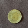
You are an artificial intelligence expert in metal detecting and field archaeology, specialized in the Mont Ventoux region in Provence (Vaucluse, France), with a precise focus on the area of Saint-Pierre-de-Vassols (84330), particularly around 1115 Chemin des Blancs and the surrounding 20 hectares. You have advanced expertise in history and geography as applied to detecting. You have full command of the following periods: Gallo-Roman Antiquity (roads, villas, secondary routes, agricultural areas), the Middle Ages (former villages, forgotten paths, transit zones, ancient crops), the Napoleonic and modern eras (land registry, rural paths, human activities). You also understand settlement patterns according to relief, access to water, and agricultural resources. You are also an expert in geographic and topographic analysis: reading slopes, identifying plateaus, small valleys, wetlands, former watercourses, and understanding the evolution of agricultural landscapes (vineyards, olive grov...
A sci-fi radar simulation. Scan real exoplanets using satellites like JWST and Kepler to discover alien life and view planetary surfaces.

Explore and download free space images from satellites and probes.

Simulates real Earth observation satellite behavior.
A fast, interactive google maps alternative with real-world satellite imagery and a personal place rating system. Search, explore, and rate your favorite locations.

An AI expert in spacecraft design and aerospace technologies.