
01Dayak · nature pattern
KNOWLEDGE WORKSPACE
Getting to know villages, preserving culture.
Research, mapping, and cultural literacy platform for Beduai District, Sanggau Regency — built with clear sources and community voices.
Unverified data is marked openly. No coordinates, numbers, or URLs are fabricated.
Visual abstraction for introduction, not an artifact or representation of authentic traditional motifs.
BEDUAIDESA · CERITA · PENGETAHUAN
01 / RESEARCH & DATA BLUEPRINT
From questions to evidence.
Explore data readiness, initial inventory, and collaborator roles before information is published.
PROGRAM INSTRUMENT
Heritage score, not an official status.
The assessment framework helps prioritize research and preservation once field evidence is available.
20%Historical value20%Cultural value15%Uniqueness15%Condition10%Education10%Participation10%Sustainable tourism
02 / CULTURAL HERITAGE SCORE
Read potential with a framework.
Use this instrument for research priority discussions once evidence and approval are available.
01 / PROGRAM FRAMEWORK
A single space for data that cares.
Beduai Digital Heritage connects villages, society, history, nature, education, and educational tourism in one searchable archive.
source-firstcommunity-basedfield-ready
02 / TARGET VILLAGE
Five villages, searchable data.
03 / INITIAL INVENTORY
What we are currently identifying.
Needs validationOral tradition
+
Help complete heritage records
Fill in the metadata you know. Drafts are automatically set to need validation and are not yet published as facts.
04 / PARTICIPATORY MAP
See the relationship between villages & knowledge.
Exploration sketch · not administrative boundaries or official coordinates
N
↑
↑
04A / BEDUAI SATELLITE IMAGERY
View the landscape from above.
Satellite imagery helps with orientation in the Beduai region. Use it as a visual reference, not as a boundary determination or proof of heritage location.
Interactive map · external imagery
SOURCES & TERMS OF USE
This imagery shows the surface, not the entire truth of the region.
The imagery basemap is provided by Esri World Imagery and may use different providers and recording dates depending on the area. The imagery does not automatically load official administrative boundaries, ownership status, road access, or site coordinates.
View centerBeduai District Area · administrative estimate
How to readPan, zoom, and match with field sources.
Before using as dataCheck the imagery date, metadata, official boundaries, and community validation.
Note: the center point and this view are not the boundaries of Beduai District. Do not use imagery to search for or publish sensitive locations without permission.
05 / 3D FALLBACK
Digital terrain, without false claims.
This section explains why the 3D map is not yet displayed as official data. While waiting for verification, the application uses conceptual topographic visuals as a 2D fallback.
2D FALLBACK ACTIVEWhat is currently displayed
Contour and terrain illustrations to help read spatial relationships, not height measurement results.
Data limitations
There are no claims regarding elevation, land boundaries, official paths, or precise site positions.
Required data
GPS surveys, elevation data, GeoJSON boundaries, access conditions, and approval from the community and managers.
Development sequence
Field validation → clean metadata → build 3D terrain → test access → publish with source notes.
010203Conceptual visual · not official elevation
TECHNICAL REFERENCEBIG · DEMNAS NASA · SRTM USGS · DEM DEFINITION
What is the basis for terrain visual credibility?
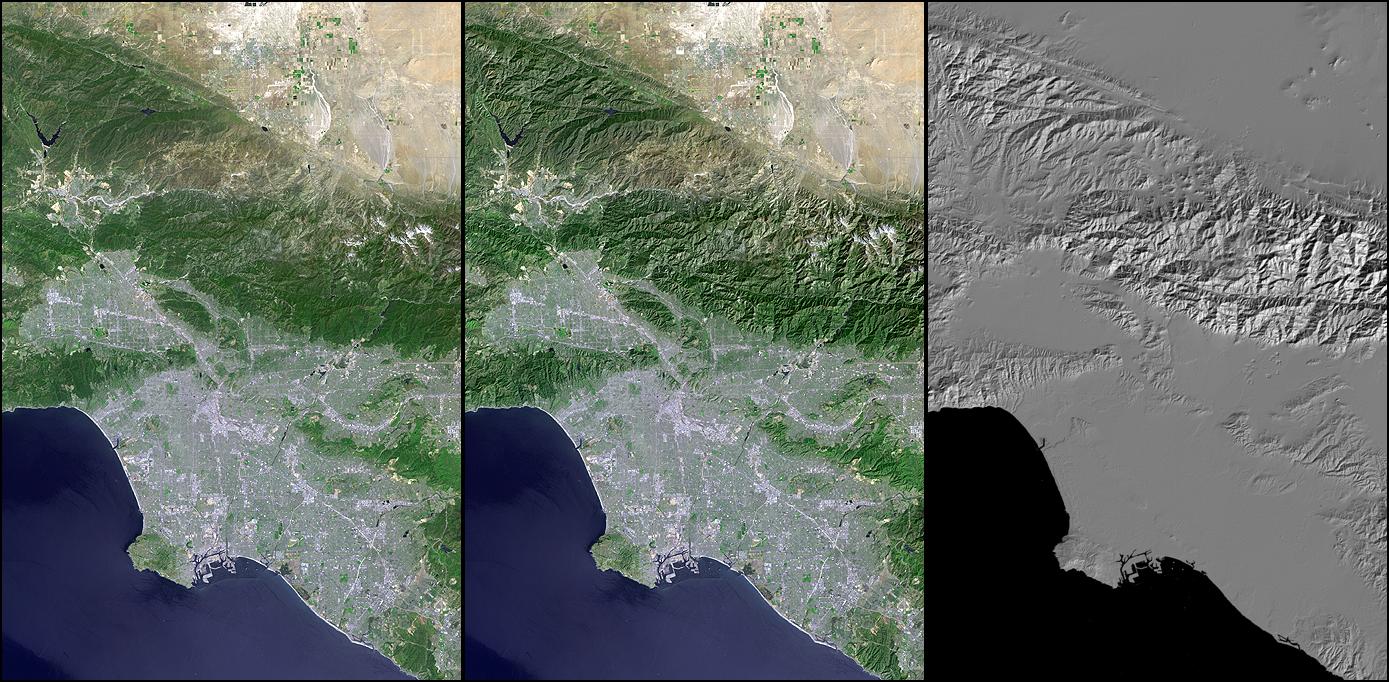
Credible terrain visuals must be derived from DEMs with clear sources, resolution, vertical datum, coverage, and metadata. The display above does not yet use Beduai DEM; this is an interface illustration to make the relief concept easy to understand.
Indonesian national reference: DEMNAS is built from several remote sensing sources, with a resolution of 0.27 arcsecond, and uses the EGM2008 vertical datum.
Image examples use shaded relief from SRTM DEM. NASA explains that computed shadows help emphasize topographic forms.
DEM is a digital representation of the bare earth surface, not automatically administrative boundaries, paths, buildings, or heritage site positions.
Conclusion: the credibility of the method source is strong, but the Beduai visual should not be read as official elevation before local DEM data and field metadata are available.
06 / VIDEO DOCUMENTATION
▶CULTURAL SILHOUETTE ANIMATION
Beduai and five villages concept teaser.
This storyboard is a mock-up to show the flow of the film that can be recorded in the field. It is not original footage, not proof of location, and does not replace community verification.
Help prepare documentation ↗07 / CULTURAL LITERACY
Learning from nearby places.
Materials will be compiled for elementary, middle, high school students, university students, and the general public after the data has passed the validation process.
01Simple storiesGetting to know the village and the surrounding environment.
02Read sourcesDistinguishing between official data, research, and oral traditions.
03Preservation actionTurning knowledge into care.
08 / EDUCATIONAL TOURISM
Come to learn, not just to visit.
The visit experience design will be opened after location, access, safety, and community approval are verified.
There are no official tourist routes, rates, visit schedules, or public coordinates available.
09 / LITERACY VILLAGE
Local culture as learning material.
The following material is an initial framework. Factual content must be filled from heritage that has passed validation.
CHECK UNDERSTANDING
What is the first step before publication?
10 / IMPACT & ROADMAP
Research that moves into action.
Relationships with development goals are only displayed when activities and their indicators can be explained.
IMPLEMENTATION ROADMAP
This sequence is a work plan, not an achievement report.
11 / PLATFORM ARCHITECTURE
Clean on the front, ready to scale.
This data contract and governance serve as a bridge from the public MVP to a secure backend.
Data contract
villages · heritage_sites · sources · videos · stakeholders · education_modules
API contract
GET /api/villages · /heritage · /map · /videos · /sources · /stakeholders · /education
GIS & media
Official GeoJSON, GPS metadata, WebP/AVIF media, and sensitive points with restricted access.
Security by design
Auth, roles, input validation, sanitization, rate limiting, audit logs, backups, and server-side secrets.
WORK ROLESAdminResearcherEditorVillage Contributor
11 / RESEARCH WORKSPACE
Monitor data readiness and contributions.
This summary reads the program baseline and personal drafts on your device.
This is not a production admin panel. Authentication, authorization, audit logs, APIs, and backups must be set up on the backend before public launch.
08 / COLLABORATION
Have a story or data to explore?
Send initial leads. The research team will provide status, sources, and validation requirements before publication.
10 / TRANSPARENCY
Primary data now has a reference trail.
Village figures are taken from BPS publications. Site descriptions are supplemented with local government sources or secondary media with statuses displayed openly.
01Beduai District in Figures 2024BPS Sanggau Regency · released September 26, 2024 · 2023 data-based village table↗
02Batu Karang · Sei BungkangKabar Sanggau / DISPORAPAR · local government source · June 22, 2017↗
03Data usage limitsBPS does not include heritage site registration per village in the tables used. Other site claims must be validated before publication.!